Index
Stage Two: Killin to Oban, ferry to Lochboisedale, South Uist.
Stage Five: Scalpay to Scalpay: cycling in Harris
Stage Six: Scalpay to Tarbert, ferry to Uig (Skye), then to Carbost via Portree
Stage Seven: Rest day in Carbost
Stage Eight: Carbost to Armadale, ferry to Mallaig
Stage Nine: Mallaig to Strontian
Stage Ten: Strontian to Killin
Stage Eleven: Killin to Tayport
Day 1: Tayport to Killin
The first day of our tour began sunny and bright, though a little cool at first. We left Tayport at about 8.30 am. Because this was the first day riding with full panniers, we decided to detour via St Michael’s crossroads, for a bit of bike practice, which turned out to be a good idea. Unfortunately the roads were quite busy at times as rush hour approached. Rather than traverse Dundee’s new traffic system, after crossing the Tay Bridge, we headed out along Riverside, and out through Invergowrie, Kingoodie and Longforgan, where we crossed the main A90 at the Longforgan underpass.
Carrying on through Knapp, and up into the Sidlaws, we were rewarded with splendid views of distant mountains.
 Once over the Sidlaws, we carried on through roads made familiar through years of Dundee Wheelers club runs, to Birnam, where we stopped at Katie’s Tearoom, one of our old favourite club run tea stops. By this time, we had over 40 miles covered, and we stopped for lunch in the form of soup and bacon and egg rolls. Katie remembered us from our many visits when we lived in Dundee and used to ride up to Birnam on a Sunday morning!
Thus fortified, we turned onto the A9 briefly, before turning onto a B road for Aberfeldy via Grandtully. This section of the route was pretty uneventful, and was by and large a pleasant ride - the sun was still shining, and it had warmed up considerably. The last four miles before Kenmore were pretty hard going, but a tea-stop (with serious carrot cake) there put us to rights, and energised us for the 17 miles along the north side of Loch Tay.
 There is a cycle route beside the loch, but it takes the minor road on the south side, which is severely undulating, and has a poor surface, so we avoided it. We reached Killin at about 4.30pm. After finding a B&B and getting cleaned up, we went out for a couple of beers and a reasonable seafood chowder.
82.06 miles in 6:38:26, average speed 12.35 mph, maximum speed 30.3 mph.
Day 2: Killin to Oban, ferry to Lochboisedale, South Uist.
We slept well, but got going early to ensure we wouldn’t miss the ferry from Oban to Lochboisdale in South Uist. It was another gloriously sunny morning, and a little warmer than the day before. We made good progress along the main trunk road thtough Crianlarich and Tyndrum, but didn’t stop until after the Cruachan Power Station (this is apparently an enormous hydroelectric power station carved inside a mountain - a bit like the base of one of those megalomaniac villains in a James Bond movie). At a cafe we packed in soup, egg and bacon rolls and apple pie, before pressing onwards.
At one point as we rode alongside Loch Awe, a pair of RAF jets came howling by at low level, very alarming, and not the only time this would happen during this holiday!
From here on, the traffic levels built up a bit, and the road undulated more severely, making it all rather heavy going into Oban. Still, we rolled through Oban to the ferry port with plenty of time to spare. We bought our tickets and had a stroll about. There was a fair amount of publicity for the BBC childrens’ programme “Balamory”, which is filmed in Tobermory on Mull, one of the islands not far from Oban.
The ferry departed at 3.30pm. Unusually, there were few birdwatchers on board - normally they afford considerable amusement as they chase from one side of the boat to the other, brandishing binoculars. This ferry crossing was the longest of our tour at over 5h. While CalMac has many goodpoints, the quality of ther catering is pretty basic, and it’s basicaly fish and chips etc, though I managed to have herring fried in oatmeal (albeit with chips!), which was rather nice. The Tourist Information office opens when the ferry arrives, and they efficiently found us a B&B about two miles down the road.
The ferry leaves Oban (from the ferry, you can see the strange Collosseum on the hill) and passes to the east of Mull, giving good views of the colourful town of Tobermory (not quite as colourful as Balamory!).

Lochboisedale is a curious and rather bleak place, consisting of a scattered collection of houses, the CalMac jetty, a few shops, a hotel, and not much else. As we cycled out of Locboisedale, the familiar settlement pattern of South Uist could be seen ahead - rather than discrete villages and settlements, the houses tend to be evenly distributed near the roads
Ferries in the Outer Hebrides are run by Caledonian MacBrayne, popularly known as CalMac. For many reasons, these services are subsidised, and represent good value, particularly for cyclists. We bought one of the Island Hopscotch tickets, which covers the four principal crossings of our trip for £35 per person, with the bike carried free.
58.71 miles in 4:39:13, average speed 12.61 mph, maximum speed 35.5 mph.
Day Three: Lochboisedale to Lochmaddy and Berneray
After a really good sleep, we woke to find the morning dry but overcast. After a hearty full fried breakfast, we set off northwards, with a gentle tail wind. Some miles up the road, we took a detour via Stonybridge, to walk on the famous silver sand beach, unfortunately not looking so glorious as on one of our previous visits because the weather had become heavily overcast. We were surprised to find large defences of boulders and shingle had been piled up between the sandy grass and fields and the beach (you can see one on the beach photo), and it was a fair old scramble to get over them. Later on, we found out why these had been put in place. Still, we walked for a while on the beach, scaring some Eider ducks. It was shame that it was such a gloomy day, but the s ands were still a sight to see. From South Uist, we rode on towards Benbecula, a landscape of small islands with lochs, all linked by causeways. As part of a recurring theme, we noticed that many of these had been damaged, with the embankments (which are made of pretty large boulders) showing sign of considerable damage. Benbecula is a strange place, seemingly more water than land. There is a considerable variety of bird life, and you can see why the birdwatchers come here (and why there is a program of hedgehog eradication - they were introduced in the 1970s, and are steadily munching their way through the eggs of ground-nesting birds, which is most of them, since there are precious few trees on the Uists). Unfortunately, we don’t have a wide knowledge of birds, but we did recognise Eider ducks and ducklings, Greylag geese and goslings and saw a fledgling cuckoo being fed by its tiny foster mother (actually, while we heard loads of cuckoos though our tour, but this was the only one we saw).
We stopped by one of the causeways and fired up the Trangia for lunch. After curry washed down with coffee, we set off again, unfortunately through a few brief flurries of drizzle. The wind got a little stronger, but fortunately remained a tailwind. Navigation on the Hebrides is rather easy, since there aren't many roads to choose from! We turned east at Clachan, and headed for Lochmaddy, over the peat bog moors of North Uist. North Uist isn't what you'd call mountainous, but it's significantly hillier than South Uist and Benbecula, although the cycling is still pretty easy. Lochmaddy is one of the CalMac ports, and ferries leave for Uig on Skye, and other destinations. We rolled in to Lochmaddy in search of a B&B, but none seemed to have vacancies. In fact there didn't seem to be very many B&Bs at all, and the one we'd used on a couple of previous visits was conspicuous by its absence (we later found out that it had burnt down!). We resorted to the Tourist Information office, who were pretty useless. Next we tried the Lochmaddy Hotel, in desperation since a double was £95 a night! They had no vacant rooms, but the receptionist was very helpful, and phoned around to find us a room in a B&B about 6 miles north, near the road to Berneray. The downside was that the landlady wouldn't be there until 6pm, and this was at about 3.30pm! We also heard bout the tremendous storm of January this year. In fact there are still large diesel generators dotted around the Hebrides, as the power lines haven't been fully replaced. A family crossing one of the causeways was washed away and killed in this storm, in which winds of over 120mph were recorded for 5-6 hours (this is not gusts of 120mph...), and which explained the damaged causeways and the storm defences on the beaches.
We left the Lochmaddy Hotel and went to the Lochmaddy arts centre to look at the exhibitions and eat a snack. Then we set off to investigate the Berneray causeway, which had opened since we were last on the Uists. The ferry to Harris now leaves from Berneray rather than North Uist. By the time we'd trundled there and back, we arrived at the B&B around 6pm. It turned out to be very comfortable, as is usually the case. We were getting a little worried by the difficulty we were having in finding B&Bs in the Hebrides – perhaps this was because we were travelling a few weeks later in the season than usual. We resolved to go back to the Lochmaddy Tourist Information office the next morning to arrange accommodation in Tarbert before we set out for the ferry. And so to bed...
61.81 miles in 5:06:36, average speed 12.09 mph, maximum speed 31.6 mph.
Day Four: Lochmaddy/Berneray to Scalpay
We were a little worried about finding accommodation in Tarbert, given the difficulty we’d had in Lochmaddy. So we decided (Plan B) that after breakfast (another full fry-up!) we’d head into Lochmaddy to see if the Tourist Information Office could arrange something for us. I was a bit doubtful given our experiences of the day before, but was persuaded. The B&B lady kindly phoned the office to check that they could do this, and to get he ball rolling before we turned up. These arrangements cannot be done solely on the phone, since a payment of 10% (deducted from the B&B) plus a £3 booking fee has to be made. Anyway, our original idea of going off to look at the machair was shelved in favour of plan B. In any case, the weather looked grey and miserable (though not raining),
Off we went, to cover the 5 miles or so to Lochmaddy. About 3 miles in there was a huge bang from the rear tyre. Closer examination revealed a split about a centimetre long just above the bead. This is a problem tandems suffer from, particularly when heavily loaded. It’s irritating, though, and necessitated removing all the rear luggage, disconnecting the drum brake, then removing the wheel before replacing the tyre and tube. Having done this, we were faced with the issue of inflation. Our trusty Zefal HPX pump had been pinched in Tayport and replaced by a Blackburn minipump in Killin. Quite frankly, the advertising blurb associated with the typical minipump are barefaced lies! I would dearly love to meet tha man who can get any tyre up to the claimed 160psi with one of those things, let alone a 32mm touring tyre to 90-100psi! Anyway, I did the best I could before carrying on to Lochmaddy.
We reached the Tourist Information office to find the lady had been phoning the B&B we'd just left, to say all she could find was a B&B on Scalpay, a small island off Harris, just east of Tarbert. We said that'd be fine, and booked two nights. The decision was made easier by being told that there was now a causeway to the island. This process took a while, and we were glad to be on our way again to Berneray to catch the ferry to Leverburgh on the south of Harris.
By this time, a stiff breeze had sprung up, and we battled along this to come trundling along the Berneray causeway with about 25 minutes to spare. The ferry, bizarrely enough, was hanging around at the old ferry terminal on the North Uist before it travelled across to the new terminal to pick up passengers. Since our last visit, when the ferry was a poxy old affair with a small seating lounge smelling faintly of warm vomit, they've upgraded to spanking new ferry with a really nice seating lounge, and nice, clean toilets. The ferry takes just under an hour to cover the very short distance to Leverburgh, since the intervening stretch is liberally populated with small islets and submerged rocks – accordingly, the ferry keeps turning to avoid them. the trip was enlivened by a group of kids who appeared to be in a Scottish folk band – whenever three or more of them were within a few few feet of each other they would break into song (the kind of song you hear on BBC Scotland Hogmanay programmes). Bu the time we left, the weather had turned windy and grey.
 We rolled off the ferry at Leverburgh and made straight for the tearoom/shop, where we first had tea and carrot cake, then shopped for some fruit and things for lunch, such as oatcakes (actually we had very nice “Hebridean Oatcakes”. Soon after leaving Leverburgh, the road became singletrack again. This slowed us right down, because many cars just won't wait in passing places. Still, the sun came out for us to admire the wonderful golden sands of the Harris beaches. We stopped above one of these to have lunch, much to the amusement of a seal, which bobbed about in the sea gawping at us.


Further on, we passed more glorious beaches, with a caravan site, then the road turns inland and starts rising. It takes you up over the rocky interior of the island – very rugged landscape. The last time we cycled this way, it was torrential rain, and we eventually squelched into a now-closed B&B in Tarbert. This time however, it was hot and sunny, and while this made the climbing seem that much easier, it was also quite hot work! The scenery at the top, where the road undulates along was stunning. After a while, the road descends quite steeply into Tarbert, which lies on a narrow isthmus between North and South Harris. We found a tearoom five minutes before closing, and were rewarded by being able to eat some food for tea. Then off along 5 or 6 miles of severely undulating road to reach Scalpay. The Scalpay causeway is actually quite an elevated bridge, and quite fun to cycle over: the B&B was very close. After unloading all our gear and showering, we wandered out for a short evening stroll. There are quite a few houses, a school, no pub (that we could see at least - unfortunately, I was rather thirsty). Oddly, down in the bay in front of our B&B was a moored or partially sunk concrete ship, being used as a jetty by the fishermen. Our B&B landlady obviously hated it, and said it was a German ship dating from WW2.
45.55 miles in 4:07:21, average speed 11.04 mph, maximum speed 40.8 mph.
Day Five: Scalpay to Scalpay: cycling in Harris
We had planned today as an easy day, and while we only covered a little over 31 miles, the roads were far from easy! Our plan was to cycle in to Tarbert (not that there was a great deal of choice in the matter!), then out along a B road to the West of Harris, which eventually reaches a place called Huishinish. We thought that this might not be a terribly flat road, but were actually quite surprised at how hard it was: it went up in short steps of extremely steep gradient. We stopped to eat a small lunch and admire the view after a bit, but it was a bit cold as the wind had swung round during the night to come in from the north. After 16 miles of slogging up and down, we decided this wasn't the best way to spend a “rest day”, and turned back towards Tarbert, where we stopped for some excellent beer (Hebridean breweries' Seaforth Ale), at a newsagent for a paper and at the tearoom for some food. Then back to the B&B in Scalpay. The evening was a gloriously sunny.
31.84 miles in 3:17:16, average speed 9.67 mph, maximum speed 41.5 mph.
Day Six: Scalpay to Tarbert, ferry to Uig (Skye), then to Carbost via Portree
Today we were to travel over to Skye, where the friends we had steayed with in Tayport prior to setting out had rented a cottage for a week of mountaineering. We woke to clear blue skies, and the water in the bay was like a mirror. After breakfast (when we had an interesting conversation with another guest who'd retired to Lewis from Kent), we loaded up the tandem and set off for Tarbert. Unfortunately, the skies had clouded over by the time we reached the ferry terminal. We checked in and hung around until they'd loaded the cars on the ferry, and we could get on. There were several cyclists on the ferry this time, in contrast to the others. The trip was really very calm, and we could see good views of Harris as it receded, and of Skye as it came closer.
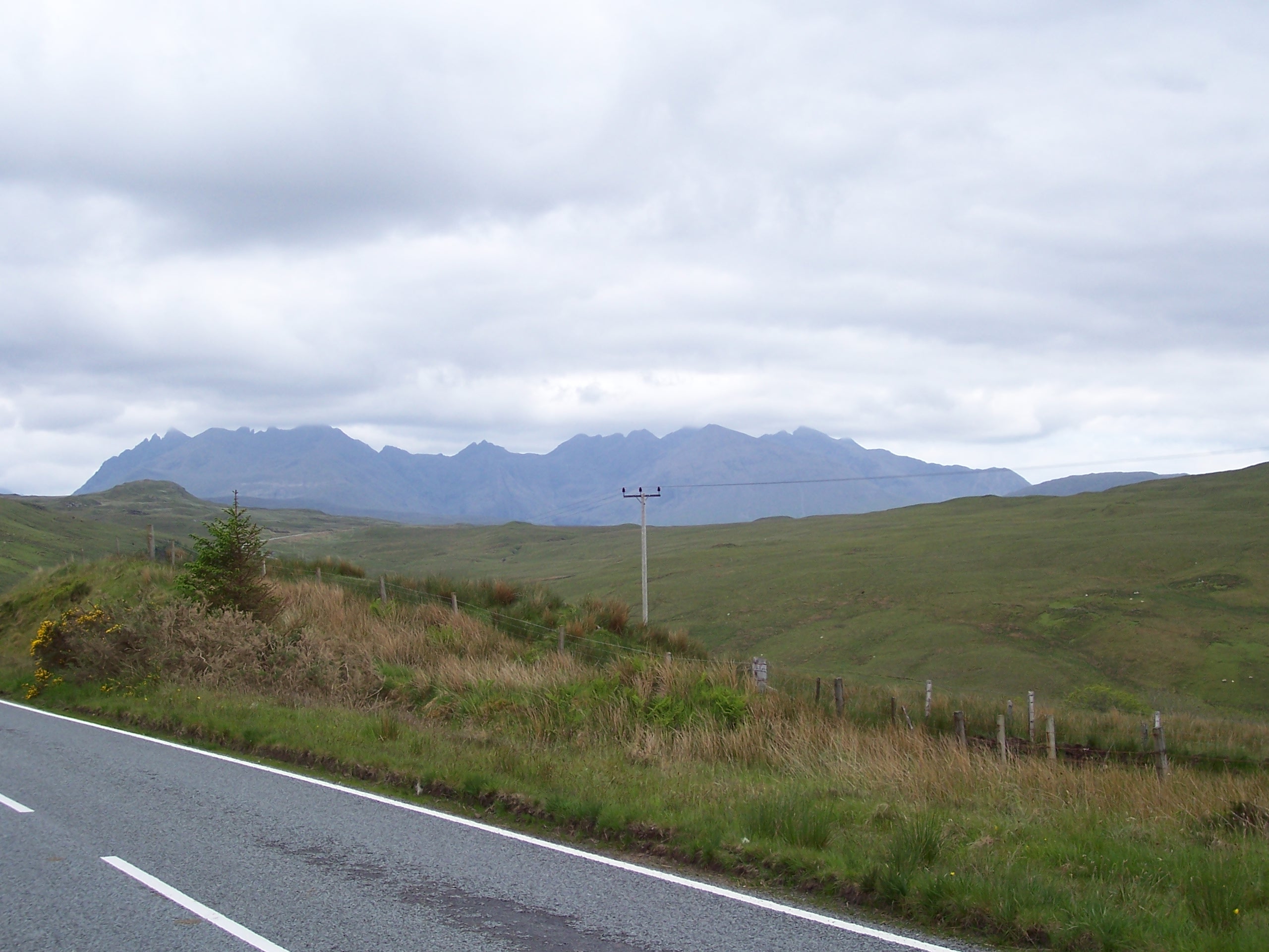
The crossing only takes about two hours, but we had to wait for the cars to disembark before we came rolling down the gangplank. The jetty is quite long, and it's just as well we weren't chased along by cars! We stopped at the Uig store for more supplies, before pressing on. We had decided to start by going to Portree to find a rumoured bike shop for some inner tubes. On the way, we saw loads of signs counting down the miles for a triathlon, but we didn't see any competitors. We found the bike shop in Portree without any great difficulty, other than the fact we found the town rather busy after the last few days! We went to a cafe for some lunch, and got talking to a guy who'd come over from Harris to run a half marathon – they's borrowed the road signs from the triathlon club, apparently! From Portree we took the road over the moor towards our destination, Carbost. This is quite a steep road at times, but we didn't have too much trouble. The route was really quite picturesque. It was still rather cold, despite having what appeared to be our own private sunny patch following us along. Near Struan, the road joins the main A road, alongside Loch Harport. This was also quite hilly, but we were rewarded with excellent views of the cloud-capped Cuillins.
The final leg to Carbost was a B road running back up the other side of the loch. We reached Carbost about 15 minutes after Will and Cath had rolled up in their car! After unpacking the tandem we spent a bit of time chatting about our holiday so for, and Will and Cath’s plans for their week of climbing. A bit later on we went to the pub down the road for a couple of beers and some excellent seafood. I had oysters and then langoustines, all excellent.
43.31 miles in 4:14:19, average speed 10.21 mph, maximum speed 39.0 mph.
Day Seven: Rest day in Carbost
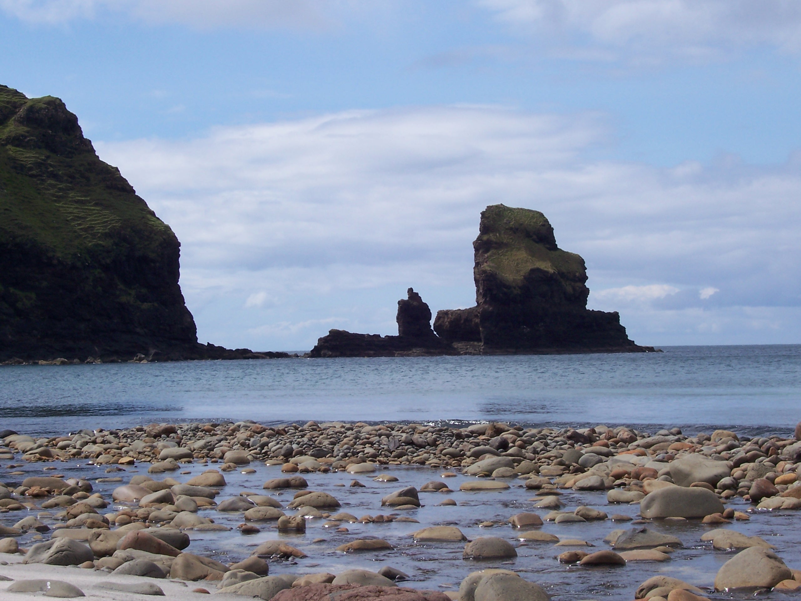
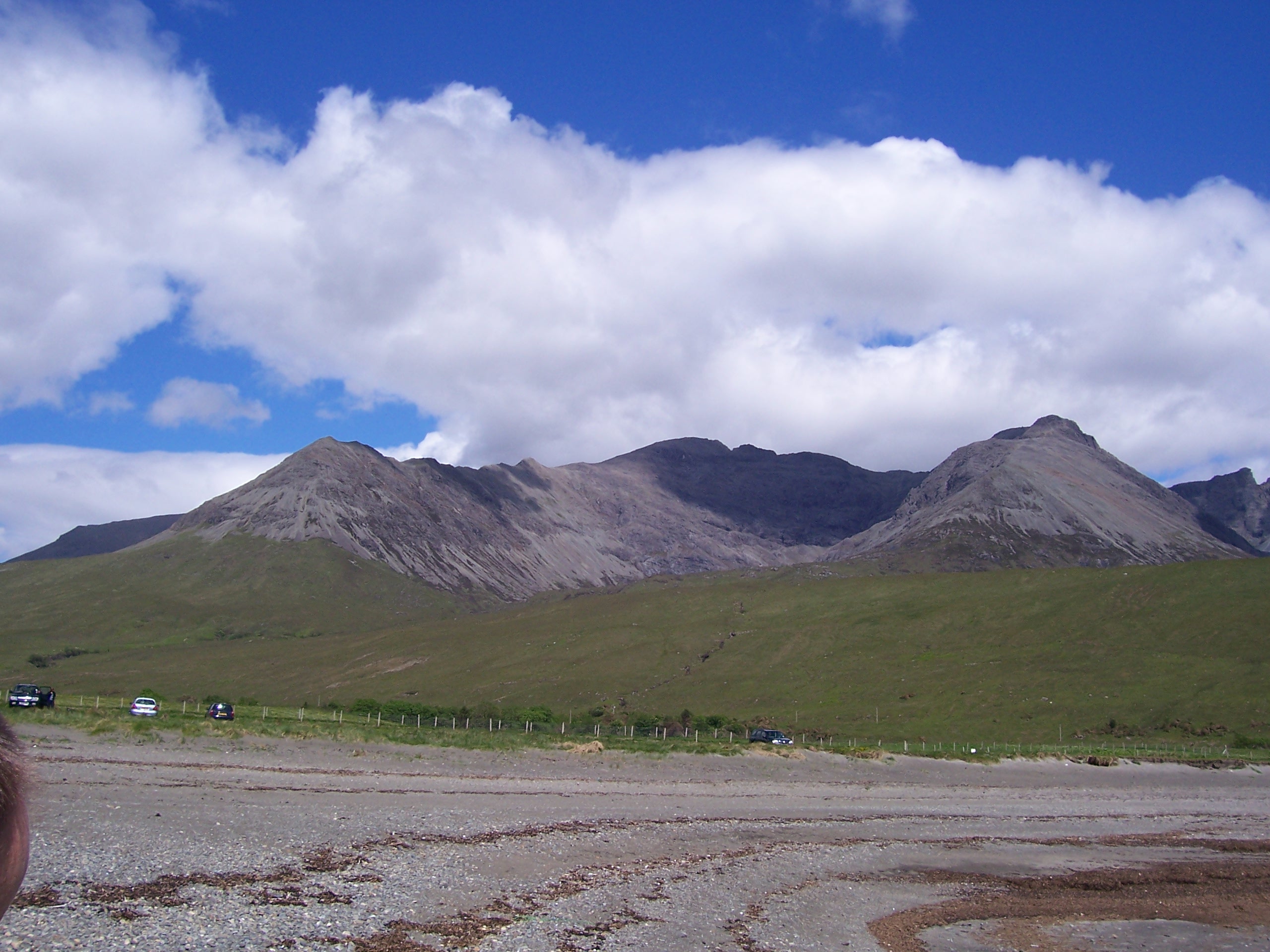
After six days in the saddle, this was a very welcome rest day! It was also something of a relief not to have a full fried breakfast as our digestive systems were beginning to rebel against such cruel and unusual punishment. It was very windy, but mostly sunny. we spent the morning driving about the area, visiting art galleries and beaches, mostly in the shadow of the Cuillins, which look absolutely forbidding from below. In fact, from the cyclist’s point of view they look not only unassailable, but positively dangerous! We went to the Sligachan Hotel, which is pretty much at the foot of the Cuillins, for lunch (Cullen Skink).
In the evening, we drove down to Broadford for dinner at the excellent Creelers restaurant (smoked venison, king scallops, chocolate mousse).
Day Eight: Carbost to Armadale, ferry to Mallaig
I woke at about 6am, but it wasn't until 6.40am that I plucked up the courage to look out of the window. The weather forecast had predicted wall to wall rain. I gritted my teeth and opened the curtains...grey, gloomy, drizzle. Oh well, I thought, could be worse! At least the wind had dropped.
By 7.10am, the rain had got much heavier, and the weather forecast was for several days of rain... Despite this we set off from Carbost at about 9.40am, by which time the rain had eased back to drizzle. There was a surprising burst of traffic that made getting going along the singletrack quite hard, possibly a combination of distillery workers heading for the Talisker distillery, anf people leaving B&Bs. In complete contrast to the day before, when the Cuillines were bathed in glorious sunshine, today the clouds were so low that the mountains were well-nigh invisible. Once on the main south road, we made good progress, with a helpful tailwind. We soon passed the Sligachan Hotel. We had originally planned to take the old coast road, but we'd checked it out in the car on the way back from dinner in Broadford the night before and found it to be in an extremely bad state of repair, so we stuck to the main road. Fortunately the three sets of roadworks didn't hinder us too much. Will and Cath had decided against climbing in the rain, and they came bowling past us with a cheery toot in the car on the way to Broadford, while we were trundling up the side of Glamaig. From here it was a rapid ride into Broadford, where we stopped for some food, and to buy some snack bars in the shop.
After this early lunch, we pressed on through Broadford, declining to squelch into the Sepentarium (a reptile centre) in favour of making good progress. We took the Armadale turn and carried along the new road, which turned out to be rather quick. During the afternoon, the weather started improving, and by the time we reached Armadale, before 2pm, it was actually quite sunny. We decided to catch the next ferry at 2.25pm. While Carol perused the delights of a knitwear shop, I took it easy in the small ferry terminal, listening to a bunch of loud German tourists, who turned out to be rather bravely driving open top sports cars to some kind of rally. It's a quick crossing to Mallaig, about 30 minutes, and we rolled off in search of a B&B, in brilliant sunshine. We found a B&B right near the harbour, and got the kit off the bike. We got cleaned up and nipped out to find something for dinner. This of course involved the consumption of beer! Dinner was more seafood – I had a seafood platter, which is always subject to what's been dredged up by the fishermen – it wasn't bad, but not the most exciting example I've had. While Mallaig was a bit bigger than I remembered it, there's not much there apart from the harbour and a rail station. Even the tourist information office closes at an inappropriate time of day.
41.81 miles in 3:22:54, average speed 12.36 mph, maximum speed 39.8 mph.
Day 9: Mallaig to Strontian
We woke to a perfect sunny morning. So good in fact that it was hard to believe all the weather forecasts predicting heavy rain. Still, despite it all, we remained defiantly optimistic (well, at least I did!). Carol managed again to avoid a full fried breakfast, and had some really unctuous local kippers. I succumbed once again to the fry-up temptation. Thus fortified, we set off down the road.
The Mallaig road has been “improved” so that it is straighter so the motorists need less skill to avoid careering off the tarmac. It was nice and wide and smooth and nearly deserted. This didn't stop one fat git in a 4x4 hooting, shouting and gesticulating that we should be on the cycle path (a cycle path that is wholly unsuitable for tandems, touring bikes, or indeed anyone using bikes to travel more than a few hundred yards). This was one of the few nasty encounters with motorists (see Day 10 for the other one) and it left a bad feeling. At Lochailort, we turned off towards Moidart, one of our favourite parts of the west of Scotland. This was where we had our first experience of cycle camping, on a weekend trip with some friends, and we've always had a soft spot for it.
We rolled along the shores of Loch Ailort, admiring the views, which were quite stunning in the brilliant sunshine – in fact, we could see the mountains of Skye quite clearly, and hoped Will and Cath were getting some climbing done! The road undulated along the loch, past low woodland on the left with a lot of bright pink flowering rhododendron growing, and fish farms in the loch to the right.Eventually, the road reared up for a stiff climb and fast descent to Loch Moidart. We stopped at this point to heat up some chili for lunch and quaff some tea and coffee. This was a little early for lunch, but it was a nice warm, spot, and we wanted a break before the weather closed in (there were clouds on the horizon...).n We set off again after lunch and soon crossed River Moidart where we'd camped on our first visit years ago. A real midgie-trap if ever there was one! Another climb took us over to Loch Shiel, where there were campsites and shops, but no bike oil (the silly high-tech stuff I'd brought was well-nigh useless). By this point, at Acharacle, the rain started as drizzle, as we climbed again over to Loch Sunart, and passed through the village of Salen. here there's a turn to a road which leads down to Arndamurchan, a really beautiful peninsula, but unfortunately we didn't have time to visit it. Instead we carried on in rain that became more persistent, or roads that were increasingly switchbacky, finally arriving at Strontian about 3pm. There didn't appear to be any B&B vacancies, so we stopped at the Tourist Information office for help. What is it with Tourist Information offices. They always seem to have staff called Morag with the intellectual capacity of a peanut. This one was useless, and nearly got a good shouting at. In the end we popped into the Strontian Hotel (we got the last room), which turned out to be a lovely 2* hotel with a bar that had a massive window overlooking Loch Sunart. By this time the rain was hammering down, and we spent a very pleasant few hours eating and drinking while admiring the view (and wondering just why that bloke was wandering aimlessly around bay the loch side in the siling rain – we never did figure that out!). Later in the evening Carol entertained herself by slaughtering midgies that had got into the room!
As an afterthought, I was reading Boswell and Johnson's 18th Century account of their tour of the Hebrides while on this cycle tour – I bet they never had to deal with stupidities like Tourist Information office.
49.54 miles in 4:33:59, average speed 10.85 mph, maximum speed 39.8 mph.
Day 10: Strontian to Killin
7.00am. This might be the wettest day of the tour so far – the forecast looks absolutely diabolical. We were woken at about 3am by an astonishingly torrential downpour coupled with gale force winds. However, by 7am it was dry and sunny. And not very windy.
5.10pm This is written in a cosy B&B in Killin after a very arduous day's cycling. We set of from Strontian in bright conditions, but it soon clouded over. The first stage was to get over to the Corran straight, where there is a ferry, and then cycle onwards to reach Killin for the night. We got to the Corran ferry in plenty of time, but as we waited for it, we got our first (and only) midgie attack. Oh, and the rain started. On the bright side, pedestrians and cyclists travel free on this ferry. Once across, we paused to sort out the map and get overshoes etc on, before cycling onwards. Our aim was to go via Glencoe and Crianlarich. So off we went in increasingly wet conditions, down the A82 trunk road through Ballachulish and past Glencoe village. By this stage we were pretty wet, and (stupidly) decided not to stop for a bite. We carried on, as the road climbed up an up and up and up through Glencoe. Fortunately the gradient isn't too severe, and neither was the amount of traffic. Despite (or event because of) the rain, Glencoe looked stunning, with massive mountain rearing up on either side, with their peaks lost in mist rain and cloud. Unfortunately, near the top there was a set of roadworks, complete with a sign saying pedestrians and cyclists should use an alternative route (like we were willing to turn round and go back...I think not). So we carried on, and made it to the top, despite a lorry's attempts to drive us off the edge of the road with impatience.
At this point I had high hopes of a decent descent, but we were thwarted by Rannoch moor, which just seemed to go on and on, gently undulating, with teeming rain. It was too wet to stop to make a cup of tea or lunch, so we struggled on, barely fortified by our remaining snack bars. We got slower and slower as the energy ran out. the road seemed never ending. The last few miles before Tyndrum were pretty ghastly, but we zoomed off the moor and into Tyndrum after about 54 miles of cycling, most of it wet. After a brief “animated discussion” about which grotty cafe to go to, we chose a self-service establishment, where we finally ate after a buch of extemely slow Spanish families made their orders. Thus replenished, we carried on through the rain (which was easing off a little) via Crianlarich to Killin. The post-prandial miles seemed to go by very quickly. We chose the first B&B we saw in Killin, and they could not have been more friendly, despite our general dampness. (In fact they put a boot-dryer in our room so we could dry out or shoes). After getting cleaned up, we popped out to look around. The B&B was right by the Falls of Dochart, where the Loch Tay’s incoming water arrives. I don’t know how big the catchment area is, but there was one heck of a lot of water tumbling along the falls that evening, after all the rain of the previous day or two. We popped into the pub near the falls – last time we visited, this had been a rather basic, old-fashioned pub. This time it had metamorphosed into a rather splendid B&B cum bistro cum restaurant cum pub. The food was excellent (as was the beer – I had a couple of pints of Ossian Ale). I ate risotto cake with goat’s cheese followed by a trio of Scottish cheeses, while Carol has salmon followed by some sort of creamy whisky custard confection for dessert. Finally, back to the B&B to conk out, but not before discovering that the forecast for the next day was pretty damned good.
72.83 miles in 5:50:51, average speed 12.45 mph, maximum speed 38.7 mph.
Day 11: Killin to Tayport
At breakfast the next morning we met couple who were on a hill-walking trip and another cyclist, who was planning to ride to Crianlarich to meet up with a friend, catch the train to Rannoch Station, then cycle back to Killin, presumably via Schiehallion. At this stage the weather was at least dry, but by the time we set out, the inevitable rain had begun. For some time we managed to stay at the leading edge of the rain, but eventually it got pretty heavy. We set out at about 9am, and started the day by climbing over Glen Ogle, which takes you over to Lochearnhead, on Loch Earn. It’s actually quite an easy ride heading south, as we did, heading north would be a bit more of a challenge. There’s a Sustrans route off to one side of the road – it seems to follow an old railway line, and appears to career off away from Lochearnhead. We never did see where it led to…
From Lochearnhead, we carried on along the north side of Loch Earn, which is quite a pretty road, and a nice level road. Pretty uneventful, except the full magnitude of the BBC’s weather forecast lies became clear at this point! We quickly reached St Fillan’s (the village at the other end of Loch Earn and carried on to Comrie, where we stopped for tea and scones. Then we stayed on the A85 trunk road (which wasn’t really too bust until Crieff, where we turned off towards Auchterarder. Here the landscape is beautifully rural – green fields,lots of livestock, but with some hills in the distance. This is near Gleneagles where the G8 summit together with attendant protests was due to take place. Near Auchterarder, we passed under the A( (one of the busiest roads in Scotland, and then through more undulating agricultural scenery, through a succession of delightful villages, until we were in sight of Perth, and our old cycling grounds from our Dundee days.
We cycled along the south side of the River Tay, stopping for a sizable lunch at our favourite café by the round tower at Abernethy (round towers are buildings of unknown purpose, quite common in Scotland and Ireland – maybe defensive, but they do look a little frail for that), then carried on. We were cycling through Wormit, where the Tay rail bridge crosses the Tay, when disaster struck – the replacement rear tyre started to give way. After only 350 miles or so! We debated what to do – we were only 5 miles from Tayport, where we’d left the car, so Carol phoned for a taxi and went to get the car, while I took refuge in a bus shelter, bodged a partial repair to the tyre, and realised how fortunate we had been that it hadn’t happened while crossing Rannoch Moor! Eventually, Carol returned with the car, we loaded up and we set off south to Edinburgh, our cycling trip complete, albeit on a somewhat unfortunate note.